SRJC Summer GIS Course - NRM 87
Next week is the start of the summer course NRM 87 - GIS Application in Natural Resources. This course, taught by Tim Pudoff, will feature introduction to the County’s new LiDAR data and emphasize resource conservation in our local watersheds. To find out more go to the course listing.
Course Description:
An introduction to the use of Geographic Information Systems (GIS) to analyze and interpret natural resources data, and to solve common conservation problems. Includes a basic introduction to arc view GIS, analysis of habitat loss for endangered species, evaluation of mineral development impacts, watershed analysis, assessing data quality, and environmental analysis of a proposed timber sale.

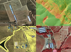 Land managers, planners, engineers, and geogeeks will be glad to hear that - for the first time ever - Sonoma County has complete countywide LiDAR data! These data, which include the point cloud, numerous raster deliverables, and simultaneously collected 4-band, 6-inch orthophotography are the first deliverables of the Sonoma County Vegetation Mapping and LiDAR Program (Sonoma Veg Map). The data are free and publicly available. Go to